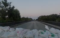
WWP Home arrow right This Event arrow right Indices: Alphabetical | Regional | Thumbnail | Map previousPrevious | Nextnext
event title
USA
portrait Ray Broussard
Sandbagged
London Avenue Canal Bridge at Robert E. Lee, New Orleans, Louisiana, USA
mini manual

This should be a panorama image.

If you can read this, something went wrong.
We support these player technologies:

With ... you can view ...
Apple QuicktimeVR
(part of Quicktime)
all contributions
Adobe Flash Player 10.1 or newer most (not all, some contributions are QTVR-only due to historical reasons)
Javascript + HTML5 / WebGL many, but depends on photographer's choice of file upload (newer event = more likely to work) and your device's capabilities. You may experience slow playback, distorted images or unexpected browser quitting if there is only limited memory/GPU power available.
[?]
Copyright © 2004 Ray Broussard, All Rights Reserved
Maritime New Media, Inc.
Previous panorama: Christian BrautfullscreenA-Z Regions ThumbnlsShow in MapNext panorama: Holger Buhr

New Orleans has 325 miles of hurricane protection levees that are mostly 18 feet above sea level. Some of these levees border the many canals through our city. We have dozens of bridges that cross these canals. All of these type bridges are slowly being replaced with bridges we won't have to sandbag each time a hurricane approaches.

Location Map Geographic Coordinates:
Latitude: 30° 1' 17.03" N
Longitude: 90° 4' 14.29" W
Precision is: High. Pinpoints the exact spot.

arrow Show at MultiMap.com [what is MultiMap?]
arrow Show at Google Maps [what is Google Maps?]
arrow Show in Google Earth* [what is Google Earth?]
* requires Google Earth
installed on your computer

Date/Time:
9/19/2004 about 7pm

Equipment:
D100/14mm/3Sixty/QTVRAS


http://www.PhotographicVR.com/wwpbridge/ Shot a second bridge pano.

http://www.PhotographicVR.com/

text
WWP Home arrow right This Event arrow right Indices: Alphabetical | Regional | Thumbnail | Map previousPrevious | Nextnext