
The Bono bridge | Le pont du Bono
Le Bono, Morbihan, Bretagne, France
11h53 GMT +1 | 2004/09/18

Loading panorama viewer ...
Configuring ...
© 2004 Pierre Converset, All Rights Reserved.
Caption
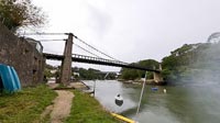
On this saturday morning, the gardeners are fussing over the gardens under a cloudy sky.Two bridges cross this arm of the sea, but here, if mention is made about the Bono bridge, everybody's thought immediately goes to the Bono suspension bridge.
Today, no trafic is allowed on this old bridge (first build in 1840) because its poor and dangerous condition. A fund was starter to promote the restoration.
You can have more information about this bridge, its history and how to contribute to the restoration on this website : http://www.pont-du-bono.com/
Ce samedi matin, au Bono, les jardiniers s'affairent dans leur jardin. Il fait gris.
Pour franchir ce bras de mer, il y a deux ponts ; mais ici, quand on parle du pont du Bono, c'est au vieux pont suspendu que l'on pense tout de suite.
Ce vieux pont (la première version date de 1840) est aujourd'hui interdit à toute circulation car en mauvais état et dangereux. Une souscription a été lancée pour aider au financement de sa rénovation.
Vous pouvez avoir plus d'informations sur ce pont et son histoire et pourquoi pas participer à sa rénovation en consultant ce site web : http://www.pont-du-bono.com/
Equipment
Nikon D70 + Sigma 8mm, monopod, PanoramaTools + PtGui
 Tap or click the zoom icon in the bottom right corner of the picture to switch between in-page and fullscreen view