

Loading panorama viewer ...
Configuring ...
© 2004 Peter O'Donnell, All Rights Reserved.
Equipment
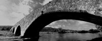
E300D, Kaidan Head, Manfrotto Tripod with Leveller, 18-55mm Lens set at 18mm, F22, ISO 100, 1/25Sec. Realviz Sticher & Photoshop.Sir Thomas' Bridge is located just outside Clonmel. It transverses
the River SuirI don't know much of the history of the bridge, but it
is easily over 200 years old and only wide enough for one car.
It can be fun watching people trying to reverse on a narrow bridge.
Boy-racers may be able to drive fast but are not so hot when it comes
to reversing.
I have deliberately left it as black & white as it conjures up
memories of days gone by.
 Tap or click the zoom icon in the bottom right corner of the picture to switch between in-page and fullscreen view