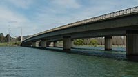

Commonwealth Avenue Bridge over Lake Burley Griffin
Canberra, ACT, Australia
2004:09:22 at 13:15 EST - Eastern Standard Time (UTC/GMT +10 hours)

Loading panorama viewer ...
Configuring ...
© 2004 Pascal Vuylsteker, All Rights Reserved.
Caption
The Commonwealth Avenue Bridge was build in 1963. Along with the Kings Avenue Bridge, and the Constitution Avenue, they form the parliamentary equilateral triangle, the heart of Canberra, according to the towns' architect Burley Griffin. The triangle corners are :
- The City Hill Surrounded by the Vernon Circle (Centre of the city).
- The Australian-American Memorial (the true corner of the triangle is the aligned roundabout nearby).
- The hearth of the Australia Capital: the Capital Hill, under which the Australian Parliament House was built.
Eventually, the angle bisector of that triangle brings you from the Parliament House to the Australian War Memorial.
Location
Australia - New Zealand / Australia
Lat: 36° 18' 29.98" S
Long: 149° 7' 39.39" E
Precision is: Unknown / Undeclared.
Equipment
Taken with a Nikon D70 digital SLR, AF-S 18-70 lens at 18mm (equivalent to 27mm), f14 at 1/160 second. Mounted on a Kaidan KIWI-L QTVR Pano Head. Stitched with RealViz Stitcher.
 Tap or click the zoom icon in the bottom right corner of the picture to switch between in-page and fullscreen view