

Loading panorama viewer ...
Configuring ...
© 2004 Michael Evans, All Rights Reserved.
Caption
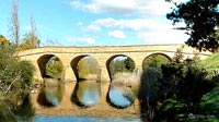
The Richmond Bridge is the oldest bridge in Australia. It was built by convicts in 1823, connecting Hobart to Port Arthur and the Tasman Peninsula. It spans the Coal River. This picture was taken looking South.
For the Equinox, I panographed four bridges around the Hobart region. I am also slowly accumulating a panorama library of Tasmanian sites
Location
Australia - New Zealand / Australia
Lat: 43° 45' 1.38" S
Long: 147° 26' 24.77" E
Precision is: Unknown / Undeclared.
Equipment
Stitched with Apple QuickTime VR Authoring Studio.
 Tap or click the zoom icon in the bottom right corner of the picture to switch between in-page and fullscreen view