
Little lost bridge
Near the northern industrial area of Amberg, Bavaria, Germany
Sept. 22, 2004 - 05:48 UTC (07:48 local time, UTC+1 + 1 hour of daylight saving time)

Loading panorama viewer ...
Configuring ...
© 2004 Markus Altendorff, All Rights Reserved.
Caption
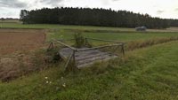
I drive by this little bridge every day on my way to work, wondering if any of people in the cars passing on the nearby road even notice it. Seems like for the last decade, nobody ever used it. Why it was built at all remains a mystery: It doesn't look like it was ever able to carry any kind of farm vehicle, and there's not that much (if any) water in the small creek, the "Krumbach", at all. So maybe it's really old, from times even before the new bridge for the road to the industrial area behind the forest was built: the wood is bleached by sun and rain, and look at the small tree already growing right through it... my best guess is that it dates back to when the nearby farmers used this strip of grass as pasture, so it may have been a bridge for cattle.This morning marked the beginning of the fall season for the district. Strong wind, low temperatures and fast moving clouds underlined that the eqinox was the end of the summer. Just before 8 a.m., the sun was crawling slowly over the forest only to disappear behind the clouds for the next days.
I shot more panoramas that day, and brighter and more colorful ones at the first day of the WWP, but I submitted this one out of pity, so to say: This bridge has no name, no history, no use and no future - a reminder of the things mankind builds and then ignores and leaves behind once they're not useful any more... (the fall season always bringing me down ;-)
View this pano at www.panoramas.de
See my other bridge panorama candidates for this WWP edition:
panoramas.de: Topic WWP200409
See my other bridge panorama candidates for this WWP edition:
panoramas.de: Topic WWP200409
Much more (and visually much more interesting) panoramas at: www.panoramas.de
Location
Lat: 49° 29' 0.94" N
Long: 11° 53' 11.1" E
Elevation: approx. 400 m above sea level
Precision is: High. Pinpoints the exact spot.
Equipment
Minolta Dimage 7 on Manfrotto 303SPH head, 32 pictures @ 28mm times 3 exposure values (of which the darkest was used for the clouds and the medium for the ground area), Stitcher 4, Photoshop 7, CubicConverter 2
Deutsche Übersetzung
Jeden Tag fahre ich an dieser kleinen Brücke vorbei, wenn ich auf dem Weg zur Arbeit bin - und frage mich, ob sie wohl irgend jemanden sonst interessiert. Sie scheint mindestens die letzten zehn Jahre nicht genutzt worden zu sein. Warum sie überhaupt gebaut wurde, bleibt ein Rätsel: Sie sieht nicht aus, als ob sie irgend eine Art von Fahrzeug tragen könnte, und so viel (oder überhaupt) Wasser findet sich auch nicht in dem kleinen Bachlauf, dem "Krumbach". Vielleicht ist sie wirklich alt, noch aus der Zeit, bevor die neue Straßenbrücke zum Industriegebiet hinter dem Wald errichtet wurde: das Holz ist von Sonne und Regen gebleicht, und seht euch den kleinen Baum an, der bereits hindurchtreibt... die plausibelste Erklärung ist wohl, dass sie noch aus der Zeit stammt, als die Bauern in der Nähe diesen Grasstreifen als Weide verwendeten; dann müsste das also eine Kuh-Brücke sein. Dieser Morgen war der Herbstanfang im Landkreis. Starker Wind, niedrige Temperatur und schnell dahinziehende Wolken unterstrichen, dass die Tag- und Nachtgleiche das Ende des Sommers ist. Kurz von acht Uhr morgens kroch die Sonne langsam über die Baumwipfel, nur um für die nächsten Tage hinter einer geschlossenen Wolkendecke zu verschwinden.
An diesem Tag habe ich noch mehrere Panoramen fotografiert, auch hellere und buntere am ersten Tag dieses WWP, aber das hier habe ich sozusagen aus Mitleid gewählt: Diese Brücke hat keinen Namen, keine Geschichte, keinen Nutzen und keine Zukunft - eine kleine Erinnerung an alle Dinge, die der Mensch baut und dann unbeachtet zurücklässt, wenn sie nicht mehr gebraucht werden... (der Herbst zieht mich immer etwas 'runter ;-)
 Tap or click the zoom icon in the bottom right corner of the picture to switch between in-page and fullscreen view