

Loading panorama viewer ...
Configuring ...
© 2004 Keith Wilson, All Rights Reserved.
Caption
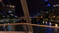
I was briefly back in Melbourne for a few days during the period of the WWP Autumn Solstice event... as the Yarra River flows through the centre of the city, there are many bridges to choose from...Looking North, you can see the main CBD buildings and in the foreground is Flinders Street station... a very historic building still used as the main terminus in Melbourne...
To the East is another famous bridge, Princes Bridge, which carries St Kilda Road... this road links Melbourne to it's trendy Southern Suburbs
Southgate is the entertainment area on the riverside... lots of restaurants and shops... markets are held in this area on most weekends...
To the west is Crown Casino and on the North side of the river is Rialto Tower (the building with the Blue lights on top)... the Tallest building in the Southern Hemisphere...
More info on Melbourne's Bridges: http://www.parkweb.vic.gov.au/resources/05_0510.pdf
Location
Australia - New Zealand / Australia
Lat: 38° 50' 10.74" S
Long: 144° 57' 54.73" E
Precision is: Unknown / Undeclared.
Equipment
Fuji S2Pro, Nikon 10.5mm Lens, Manfrotto Tripod and 303Plus Pano HeadSix Images stitched with PTGui and converted to .MOV with Panocube
 Tap or click the zoom icon in the bottom right corner of the picture to switch between in-page and fullscreen view