
Brooklyn Bridge NYC
New York City, New York, USA
6:51pm Eastern Daylight Time, 19 September 2004

Loading panorama viewer ...
Configuring ...
© 2004 Jook Leung, All Rights Reserved.
Caption
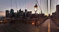
The Brooklyn Bridge is the most famous of three bridges spanning the East River between Manhattan and Brooklyn. It has probably the most traveled pedestrian traffic of any suspension bridge. The broad promenade above the roadway has lanes for walkers and bikers. Visitors to the bridge will probably stop here to gaze westward at the lower Manhattan skyline and remember how it once looked before September 11, 2001. When the Twin Towers fell and when the city suffered a region-wide electrical power blackout on August 13, 2003, this bridge was an escape route for thousands of city folks. The wooden walkway shows the wear and tear of its daily foot traffic.
I wanted to capture this twilight panorama in contrast to other daytime scenes of the bridge. Harsh shadows and distracting details drop away as the sun sets. The sky glows warm and the city lights come on.
Here are links to two of my other favorite QuickTime VR panoramas taken with the Brooklyn Bridge in view. Looking to the south on the Manhattan side is South Street Seaport at Pier 17 and on the Brooklyn side is Fulton Ferry Landing.
My 360vr.com website has many more panoramas by me.
Equipment
Hardware: Fuji S2 camera, Nikkor 8mm/2.8 lens. Exposure: f4 at 1/8 second, ISO 400.Software: PTMac and Panorama Tools. Additional post-production with PhotoShop, CubicConverter and CubicConnecter.
 Tap or click the zoom icon in the bottom right corner of the picture to switch between in-page and fullscreen view