
Granville Island
Vancouver, British Columbia, Canada
12:30am Pacific Daylight Time, 21 September 2004

Loading panorama viewer ...
Configuring ...
© 2004 Jeff Pelletier, All Rights Reserved.
Caption
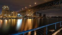
Granville Island attracts an estimated 10.5 million visitors each year - making it Vancouver's busiest attraction. With a Public Market, an art school, shops, restaurants, theatres, galleries, and a hotel, this island sits directly under the Granville Street Bridge. The Burrard Street bridge can also be seen.
Basetwo Media produces high quality VR Photography in and around Vancouver, BC Canada.
Location
USA-Canada / Canada-British Columbia
Lat: 49° 16' 21.8" N
Long: 124° 9' 3.8" W
Precision is: Unknown / Undeclared.
Equipment
Hardware: Nikon D70, 18-70mm lens, Manfrotto 303 Pan HeadSoftware: Realviz Stitcher 3.5, Adobe Photoshop CS
 Tap or click the zoom icon in the bottom right corner of the picture to switch between in-page and fullscreen view