WWP Home arrow right This Event arrow right Indices: Alphabetical | Regional | Thumbnail | Map previousPrevious | Nextnext
event title
Europe
placeholder Holger Buhr
The "Deutzer Brücke" of Cologne
Colgne, Germany
mini manual

This should be a panorama image.

If you can read this, something went wrong.
We support these player technologies:

With ... you can view ...
Apple QuicktimeVR
(part of Quicktime)
all contributions
Adobe Flash Player 10.1 or newer most (not all, some contributions are QTVR-only due to historical reasons)
Javascript + HTML5 / WebGL many, but depends on photographer's choice of file upload (newer event = more likely to work) and your device's capabilities. You may experience slow playback, distorted images or unexpected browser quitting if there is only limited memory/GPU power available.
[?]
Copyright © 2004 Holger Buhr, All Rights Reserved
Previous panorama: Ray BroussardfullscreenA-Z Regions ThumbnlsShow in MapNext panorama: Betka Burger

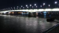
Build 1913-1915 as the "Hindenburgbrücke". The bridge broke down in 1945, while it was repaired because of the bombardment in World War II. Rebuild between 1947 and 1948. Total lenght: 437 m. Nowadays used for cars and trams.

Location Map Geographic Coordinates:
Latitude: 50° 56' 32.3" N
Longitude: 6° 56' 5.6" E
arrow Show at MultiMap.com [what is MultiMap?]
arrow Show at Google Maps [what is Google Maps?]
arrow Show in Google Earth* [what is Google Earth?]
* requires Google Earth
installed on your computer

Equipment:
Canon G5
Manfrotto tripod
Software: Apple Quick Time Authoring Studio


text
WWP Home arrow right This Event arrow right Indices: Alphabetical | Regional | Thumbnail | Map previousPrevious | Nextnext