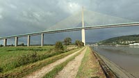

Pont de Brotonne
near Caudebec-en-Caux, Seine-Maritime, France
10:05 CEST, 19 September 2004

Loading panorama viewer ...
Configuring ...
© 2004 Harald Walker, All Rights Reserved.
Caption
The Pont de Brotonne is a cable-stayed bridge across the river Seine, connecting the department of Haute-Normandie with Seine-Maritime. It was completed in 1977, has a main span of 320m and a clearance of 50m.
More panoramas of Seine bridges in Normandy.
Equipment
Fujufilm FinePix S2Pro, Sigma 15-30mm, Manfrotto 303 pan head
 Tap or click the zoom icon in the bottom right corner of the picture to switch between in-page and fullscreen view