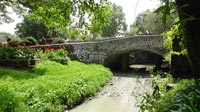

Puente de Panzacola,
Coyoacan, México City, México
Sunday, 19 september 2004. 11:00 local time (GMT -5, daylight saving time)

Loading panorama viewer ...
Configuring ...
© 2004 Felipe González, All Rights Reserved.
Caption
The river that runs through the Panzacola Bridge is the last open air river in México City. It measures about 500 meters and carries mainly rain and sewage waters. The San Antonio Panzacola church is the building seen next to the bridge. Equipment
Sony DSC s85 with Raynox Fisheye adapter. Vanta Tripod and home built pano head.
 Tap or click the zoom icon in the bottom right corner of the picture to switch between in-page and fullscreen view