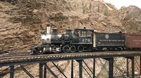

Cimarron Canyon D & RG Engine 278 Trestle Exhibit
Curecanti National Recreation Area, about 20 Miles East of Montrose, Colorado, USA
September 19, 2004 1240 PM MDT

Loading panorama viewer ...
Configuring ...
© 2004 Charles Carstensen, All Rights Reserved.
Caption
Curecanti National Recreation Area Colorado is located East of Montrose in the Black Canyon of the Gunnison National Park, USA. This is a very deep natural canyon formed out of volcanic eruptions 30 million years ago. The Gunnison River cut through the volcanic rock making it into a fjord-like character. There are steep rock walls, rock layers, and spires remaining.Three man made dams manage the river water flow along with electric generators to harness the power supplying electricity to the surrounding cities, and the United States power grid.
An historic narrow gauge railroad was constructed starting in the mid 1800's. This Durango and Rio Grande Railroad operated full time from 1882 to 1949 when the track was decommissioned. The track, bridges, and supporting equipment was torn up, grade paved into vehicle roadway or submerged in water by the new dams. Only this Engine #278 and the original trestle bridge remain as an outdoor exhibit. Unfortunately, the National Park Service, U. S. Department of the Interior, is allowing the engine to fall into disrepair.
This railroad was a very important part of the development of western Colorado. It carried cattle for the east, agricultural products, and mining equipment. The paved road you see in the image is the old railroad bed.
More Panos here
The Carstensen Index WWP
Equipment
Canon G5 digital camera, WC-DC58N Wide Converter, CRW original capture, Photoshop CS, Stiched in QTVRAS, Quicktime Pro forfinal preparation.
 Tap or click the zoom icon in the bottom right corner of the picture to switch between in-page and fullscreen view