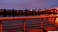

Cambie Bridge - As viewed from the Sea Wall
Vancouver, British Columbia, Canada
5:30 A.M. (Pacific Standard Time)

Loading panorama viewer ...
Configuring ...
© 2004 Charles Ed Aguilar, All Rights Reserved.
Caption
This famous Sea Wall strip, captures the beauty of Cambie Bridge. The Sea Wall, completed, around Stanley Park, after 32 years, entertains, and thrills, Vancouverites, and visitors, night and day, summer and winter, to this day. This section of seawall is mostly residential and quite pleasant even after dark. This seawall is what every Vancouverite shows off to their out of town friends when they visit.
Location
USA-Canada / Canada-British Columbia
Lat: 49° 15' 42.5" N
Long: 124° 7' 49" W
Precision is: Unknown / Undeclared.
Equipment
 Tap or click the zoom icon in the bottom right corner of the picture to switch between in-page and fullscreen view