WWP Home arrow right This Event arrow right Indices: Alphabetical | Regional | Thumbnail | Map previousPrevious | Nextnext
event title
Europe
portrait Betka Burger
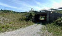
Most prezivetja (The bridge of the survival)
Notranjska Region, Slovenia
mini manual

This should be a panorama image.

If you can read this, something went wrong.
We support these player technologies:

With ... you can view ...
Apple QuicktimeVR
(part of Quicktime)
all contributions
Adobe Flash Player 10.1 or newer most (not all, some contributions are QTVR-only due to historical reasons)
Javascript + HTML5 / WebGL many, but depends on photographer's choice of file upload (newer event = more likely to work) and your device's capabilities. You may experience slow playback, distorted images or unexpected browser quitting if there is only limited memory/GPU power available.
[?]
Copyright © 2004 Betka Burger, All Rights Reserved
Previous panorama: Holger BuhrfullscreenA-Z Regions ThumbnlsShow in MapNext panorama: Boštjan Burger

There use to be a prime forest with the habitat of different animal species. Then had come a man and separated the forest with the highway. The new border could be wide as an ocean... but there are little and ugly bridges, below which are important passages for animals from one side of the forest to the other...
The highway leads between the forests of Šakov gric and Cerovica, only 2 km westward from Rakov Škocjan.

Location Map Geographic Coordinates:
Latitude: 45° 48' 33" N
Longitude: 14° 16' 57" E
arrow Show at MultiMap.com [what is MultiMap?]
arrow Show at Google Maps [what is Google Maps?]
arrow Show in Google Earth* [what is Google Earth?]
* requires Google Earth
installed on your computer

Date/Time:
19th September 2004 / 13:40 CET

Equipment:
Nikon 990 / WC-63 wide adapter (ekv. 24 mm) / Manfrotto tripod with QTVR head / stiched with Photovista


here

here

text
WWP Home arrow right This Event arrow right Indices: Alphabetical | Regional | Thumbnail | Map previousPrevious | Nextnext