

Loading panorama viewer ...
Configuring ...
© 2011 Pat Swovelin, All Rights Reserved.
Caption
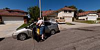
My son, Preston, was heading up to San Francisco to rehearse for a week and a half for an über-modern dance production at CalArts (California Institute of the Arts) in late July.Just to add some excitement to his upcoming 6-hour drive the girl who lives down the street made a U-turn behind Preston's car and stalled. What appeared to be smoke, a lot of smoke, was coming out from under the hood and I asked her if it was on fire. She said, "No, it's just steam. It won't start." Well I'm looking at a mixture of water and oil on the street and clearly it wasn't steam because she'd fried the engine (it'd seized, which was why it wouldn't start). If you look at the street behind Preston's car you can see where her car bled to death. Her dad walked up and opened the hood to check it out (you know, in the typical guy-fashion of pop the hood and stare at it and maybe it'll fix itself) and even more smoke came out. He leaned in and said "It's on fire!" I looked, without leaning in in case it exploded in a fireball, and the back of the engine/top of the transmission was on fire. I ran into the house, got a fire extinguisher from the kitchen (like ALL of you have, right?) and put it out. Had I not had an extinguisher the car would've been fully engulfed in flames by the time the Fire Department got there.
We all pushed it backwards into the middle of the street then gave it a push so she could coast it downhill and park it at the curb (you can see it just down the street from her dad's white pick-up truck). The next time it moves will be on the back of a tow truck because "It's dead, Jim."
After all of that excitement Preston's drive was, thankfully, uneventful.
Location
Lat: 34° 25' 48.81" N
Long: 119° 25' 43.15" W
Elevation: 1,598 feet
Precision is: High. Pinpoints the exact spot.
Equipment
Canon EOS 450D (Digital Rebel XSi), Sigma 8mm F3.5 EX DG Circular Fisheye lens, Nodal Ninja R-1 panohead, Manfrotto 190XPROB tripod, Pixel RW-221 wireless remote control, ISO 100, f/8, 1/400 second exposure, Adobe Bridge CS5, Adobe Camera Raw 6.4.1.145, Adobe Photoshop CS5 Extended x64, PTGui Pro 9.0.4, Pano2VR 3.0 64bit, NBNC, PDL
 Tap or click the zoom icon in the bottom right corner of the picture to switch between in-page and fullscreen view