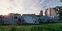

Bungalows in Munich's Olympic Village
Munich, Germany
June 21, 2011, 18:40 UTC (20:40 local time)

Loading panorama viewer ...
Configuring ...
© 2011 Carl von Einem, All Rights Reserved.
Caption
This panorama represents two kinds of virtual families: first of all the athletes of the so-called Olympic family who actually were the reason to build this group of bungalows and tower blocks very close to the Olympic sports facilities. Here they all experienced some very happy and at the same time tragic days. After the games the cubical bungalows as well as one tower block and several of the terraced buildings of the Olympic village turned into a residential area for students who until today form another sort of temporary family. The bungalows' inhabitants have a contractually accorded right to design their respective façade which makes this place actually one of the most colorful areas throughout the city of Munich.
The ensemble of buildings is still known as Olympic village but is also referred to as student's village and even includes a disco, a pub, a café and a cinema. When a complete overhaul of the buildings was essential to improve accommodation as well as energy savings, most of the bungalows had to be rebuilt in the same style during the last couple of years, since this is as a whole already considered a historical monument. That project is still in progress as you can see.
The surrounding park can be used for all kinds of leisure activities, apparently including slacklining.
Location
Lat: 48° 10' 42.6" N
Long: 11° 33' 9.2" E
Elevation: 514 m (1686 ft)
Precision is: High. Pinpoints the exact spot.
Equipment
- camera:
Zeiss-Ikon SW 35mm format rangefinder camera
lens:
Voigtländer 12 mm Heliar
2 rows of 6 images (plus nadir and zenith) lead to plenty of overlap
film:
Kodak Ektar 100 ISO color negative film
- panohead:
Novoflex (still with that antique Manfrotto "300" rotator)
- tripod:
Novoflex BasicBall (with Minipod Extension Set)
- 16-bit scans:
Nikon LS-4000 ED w/ SA-30 film roll adapter (SilverFast Ai scan software)
- stitching software:
Hugin 2011.0.1 (on Mac OS X 10.6)
- additional software:
Photoshop CS5
only used to apply masks to the scans, add a "watermark" and scale down the equirect prior to uploading (but no further retouching - hugin/enblend did a perfect job)
 Tap or click the zoom icon in the bottom right corner of the picture to switch between in-page and fullscreen view