
Shiomibashi Station
Sakuragawa Naniwa-ku Osaka, Japan
June 27, 2010, -02:15 UTC (11:15 local time)

Loading panorama viewer ...
Configuring ...
© 2010 Yasuhiro Muranaka, All Rights Reserved.
Caption
Shiomibashi Station is a starting station of alias Shiomibashi Line of the Nankai Electric Railway that connects everything from this station to Kishinosato-Tamade Station. It is an original part of Nankai Koya Line and a starting point of Koya Line on the pretext now. However, Koya Line and the railway track were divided into parts by Osaka city's continuous solidification of Nankai Line in 1985 on the boundary of Kishinosato-Tamade Station. The present atmosphere is like the terminal station in the local line rather than the door entrance to "Koyasan" the world heritage.
Shiomibashi Station having lost the function as the terminal depends on advancement and Koya railway of Koya Line having amalgamated with Nankai electric railway. The tie line from Koya Line to the Nankai Line Namba district is set up in Kishinosato Station (present Kishinosato-Tamade Station). Most trains of the Koya Line are changed to Nankai Namba Station arrival and departure that was near the center part in Osaka at this time, and, as a result, it can be said that the function as the door entrance of Shiomibashi Station was lost in 1925.
When a present station compares the function as the terminal at this station with Namba who not is, and functioned both nominally and virtually as a door entrance of each line in the Nankai Electric Railway since prewar days at the time of that completion by the one built after the Second World War, the build of the station is too simple.
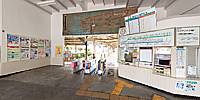
However, the issue of a ticket window with a sightseeing route map and elegance big as it is shown that it was the other door entrance of the Nankai Erectric Railway of two large trunk lines before on the inside and the corner of the station remains now, and the past of this station is told.
Equipment
Camera Canon EOS 5D Mark2
Lens Sigma 15mm f/2.8 EX DG Diagonal Fisheye
Pano Head Nodal Ninja 5
Tripod Manfrotto 055MF
Stitching Software PTGui v8.3.3
Photo Editing Software Adobe Photoshop CS3
 Tap or click the zoom icon in the bottom right corner of the picture to switch between in-page and fullscreen view