
Forgotten Farm
The Greenbelt Ottawa, Ontario, Canada
June 25, 2010, about 2:00 pm EST (14:00)

Loading panorama viewer ...
Configuring ...
© 2010 Robert Agnel, All Rights Reserved.
Caption
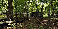
This forgotten place is an abandoned farm located in the greenbelt just off the Trans-Canada trail between the communities of Bells Corners and Kanata within the City of Ottawa.The greenbelt is 20,350 hectares surrounding the metro area with over 100 kilometers (60 miles) of trails offering walking, hiking and cycling. The forgotten farm is situated on the southern most extent of the Canadian Shield the oldest rocks on the planet, some dating back 4.5 billion years.
The panorama opens looking at the log barn. The farm house is long gone, with only the foundation still visible. The pioneer farm consisted of a second log barn, hand-dug well, apple trees and fields. This farm homestead was settled in the years after 1852 and probably abandoned before 1950. Against a tree you will notice a pile of artifacts (junk) left by a later family. This forgotten farm was originally located in Nepean Township, Carleton County in the Province of Ontario Canada. In 2001 this region was dissolved to create the amalgamated City of Ottawa.
Ottawa, the capital city of Canada, is also the agricultural capital of Eastern Ontario. Ottawa's rural area covers 2,230 km2 (860 square miles) about 80% of the total city area. Within the rural area there are twenty-six villages. Forty percent of the Ottawa's rural area is farmland, growing corn, soybeans, hay with many family farms and a growing agri-tourism industry.
The Ottawa Valley Farm Show is Ontario's longest running agricultural and rural exhibition.
Agriculture Canada's experimental farm is located within the urban center of Ottawa.
City of Ottawa Quick Facts
Location
Lat: 45° 19' 14.18" N
Long: 76° 52' 38.18" W
Elevation: 103 m
Precision is: Medium. Nearby, but not to the last decimal.
Equipment
Nikon D90, Nikkor 10.5mm lens, Nikon MC-DC2 remote control, Stitcher Unlimited, Pano2VR, PhotoShop CS4, 360Precision Atome, Manfrotto 055XDB
 Tap or click the zoom icon in the bottom right corner of the picture to switch between in-page and fullscreen view