
Forgotten Forest
Waima, Waitakere City, Aotearoa/New Zealand
Tuesday, June 22, 2010, 12:43 pm NZST

Loading panorama viewer ...
Configuring ...
© 2010 Michael Bajko,
Some Rights Reserved.

Caption
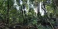
This Kauri tree sits in a small triangular reserve surrounded by suburbia. The black pipework is to channel the storm water from that surrounding tin and tarmac so it doesn't cause havoc in the valley. This is rainforest country, and boy can it rain.Approaching nine-hundred-years-old the Kauri tree is a remnant from a Forgotten Forest, a survivor of 19th Century clear-fellers, and the only survivor in the southern valleys of the Waitakere Ranges. These ranges that make up half of Waitakere City's area look lush and verdant with mature rainforests. The fact is that just 170 years ago it was quite a different forest that clothed them. Back then it was the realm of the Kauri (Agathus Australis), able to reach an age of over 2,000 years, and though not nearly as tall, carrying a greater mass than the Giant Sequoias of North America. These Kauri were from the ancient Araucariaceae family of conifers, a group once widespread during the Jurassic period, directly descended from Gondwanaland.
The British Navy was the first to exploit these forests for their sailing ships, then the clear-fellers moved in. The settlements of the North Island were built from the timber and it was exported to Sydney, Melbourne, Hong Kong, Shanghai, San Francisco and as far away as London.
The regeneration that has followed, though containing many young Kauri, predominate with Broadleaf, evolutionally younger, faster growing and more aggressive for land and light.
It is doubtful if anything like the Forgotten Forest will be seen again in the Waitakere Ranges.
For more info onthe Forgotten Forest please check out
http://foto.bajko.net/forgottenforest
Location
Australia - New Zealand / New Zealand
Lat: 37° 57' 29.33" S
Long: 174° 38' 36.42" E
Elevation: 88 meters
Precision is: Unknown / Undeclared.
Equipment
Nikon D90, Nikkor 10.5mm, Panosaurus, Slik AMT tripod, PC P4, PTGui Pro 8.3.10, Photoshop CS3 Extended
 Tap or click the zoom icon in the bottom right corner of the picture to switch between in-page and fullscreen view