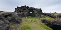

Seltangar – Abandoned Fishing Station
Krýsuvík, Reykjanes Peninsula, Iceland
June 24, 2010, 20:24:33

Loading panorama viewer ...
Configuring ...
© 2010 Martin Sammtleben, All Rights Reserved.
Caption
The barren south coast of Reykjanes Peninsula is characterised by vast stretches of lava formations, mountains and steep cliffs. However there are some spots that provide easier access to the sea making them suitable for fishing.Seltangar is one of them. It's an ancient fishing station, used from the Middle Ages until 1884. From here locals rowed out to sea in open boats to fish. They also built extensive facilities such as huts and sheds where they stored stockfish.
They took advantage of what the location had to offer: natural lava cavities were used as storage space and the lava rocks proved to be ideal building material for shelters, some of which still stand to this very day.
On a side note, Seltangar was notorious for being haunted by an especially malevolent ghost called Tanga Tómas during the 19th Century.
See more panoramic views of the area.
Equipment
Full-frame DSLR, 20mm lens, software: Lightroom, Photoshop, Apple QTVRAS
 Tap or click the zoom icon in the bottom right corner of the picture to switch between in-page and fullscreen view