

Loading panorama viewer ...
Configuring ...
© 2010 Mahmood Hamidi, All Rights Reserved.
Caption
Where the bike path is now, the old Härad's Road (Häradsvägen) extended in the past, which was an important route. It went from Lövsta, where the ferry to Mälar Islands is located, and Barkarby, where the highway ran past Västmanland. Nine of the twelve Järfälla stones have stood along the road, indicating that it was important already during the Viking era (800–1050 AD), the time Runestones were erected.
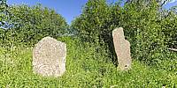
Here there are two runestones at their original location.
The rune texts on the left stone reads:
"Spjällbode" and Une let erect the stone after Tidkume, Ingetora's husband.
The rune texts on the right stone reads:
Helga and Holmfrid let erect this stone after Holm, their father.
The first stone was erected by two sons, in memory of their father, and the second of two daughters. Runestones do not mark where the two fathers are buried, but were set up as memorials.
The important road, as well as the people after whom the stones were erected, are since long time forgotten.
About Runestones:
A runestone is typically a raised stone with a runic inscription, but the term can also be applied to inscriptions on boulders and on bedrock. The tradition began in the 4th Century, and it lasted into the 12th Century, but most of the runestones date from the late Viking Age. Most runestones are located in Scandinavia, but there are also scattered runestones in locations that were visited by Norsemen during the Viking Age. Runestones are often memorials to deceased men. Runestones were usually brightly colored when erected, though this is no longer evident as the color has worn off.
Equipment
Nikon D700, Nikon Nikkor 10.5mm fisheye, 360Precision Atome bracket, Tripod.
 Tap or click the zoom icon in the bottom right corner of the picture to switch between in-page and fullscreen view