

Loading panorama viewer ...
Configuring ...
© 2010 Jim Cole, All Rights Reserved.
Caption
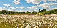
Camp Adair was a US Army training facility in World War 2. After the war it served several other purposes, but little remains of any of these uses today. Virtually all that remains of a facility housing nearly 40,000 people are a few small concrete remnants. Without local informational signs, the place would now be nearly forgotten.Today instead of army barracks, the area is now the E. E. Wilson Wildlife Area. Instead of bunkers, there are viewing blinds for watching wildlife; instead of roads, trails; instead of training facilities, fishing ponds. In addition, once forgotten wetlands are being restored as nature reclaims the area more and more completely.
The few concrete structures visible in this picture are typical of the remaining ones; it takes effort to find them. As they continue to fade away, we enjoy meadows of wild daisies, groves of trees, and active marshes.
(The spot was trampled already when I got there. :-) )
Location
Lat: 44° 41' 47.67" N
Long: 124° 13' 5.24" W
Elevation: 46 m
Precision is: Unknown / Undeclared.
Equipment
Nikon D300, Nikkor 10.5mm fisheye, Nodal Ninja 5, PTGui, Photoshop
 Tap or click the zoom icon in the bottom right corner of the picture to switch between in-page and fullscreen view