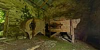

Threshing Barn at Sharagore
Sharagore, near Dunree, County Donegal, Ireland, UK
June 24, 2010, 14:00 UTC

Loading panorama viewer ...
Configuring ...
© 2010 George Row, All Rights Reserved.
Caption
Sharagore literally means, something like: "The grazing field for goats." This was once a small family-farm. But decades have passed since the fields here has been actively farmed. Some years ago the land was sold to people from the nearby city who may someday build a house on the site. The threshing machines in this barn stood idle for many years before that.
Until the 1950s the threshers would have been driven by horse-power. The old neighbour who came past while I was taking the photographs said that when he was a boy the horses were pensioned off and the threshers were driven by an engine that stood outside in the yard with a drive shaft coming through the wall. His main memory was of the deafening noise that it all made.
A Scotsman Andrew Meikle is generally acknowledged as having invented the threshing machine towards the end of the 18th Century.
The Household Cyclopedia of 1881 had this to say about it: “The thrashing machine is the most valuable implement in the farmer's possession, and one which adds more to the general produce of the country, than any invention hitherto devised. The saving of manual labor thereby obtained is almost incalculable; while the work is performed in a much more perfect manner than was formerly practicable ...”
This threshing barn is a place forgotten several times over.
Prints are available via my website: veryderry.com
Lots more panoramas of Ireland on my website: veryIreland.com
Location
Lat: 55° 11' 30.12" N
Long: 8° 31' 30.6" W
Elevation: 50m
Precision is: Medium. Nearby, but not to the last decimal.
Equipment
Shot with a Canon EOS 5D, Zenitar 16mm fisheye f/2.8 lens. The camera was mounted on a Kaiden Kiwi panorama adapter on a Manfrotto 190XDB tripod.Horizontal photographs were taken at 60° angles and also a floor and roof shot. Each "shot" consisted of three bracketed exposures. Extra shots were taken of view out the door.
A total of 27 separate images were combined using Hugin in order to achieve this High Dynamic Range type result.
 Tap or click the zoom icon in the bottom right corner of the picture to switch between in-page and fullscreen view