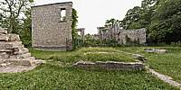

The Hermitage
Dundas Valley Conservation Area, Dundas, Ontario
June 25, 2010, 18:30 EST

Loading panorama viewer ...
Configuring ...
© 2010 Francis Fougere, All Rights Reserved.
Caption
The HermitageRuins are all that remain of the Hermitage, a once magnificent stone mansion that was built in 1855 by George Gordon Browne Leith. The stones used in construction were quarried from local sites; the red bricks from the Dundas Valley and the limestone sills from the Credit River Valley. Look closely at the stones of the ruins, and you may be able to find fossils of sea creatures and plant life.The last resident of the Hermitage was Mrs. Alma Dick Lauder, daughter of the Leiths. In 1934 the Hermitage was destroyed by fire. Mrs. Lauder built a small house within the ruins and continued to live there until her death in 1942.
The Dundas Valley Conservation Area
The Dundas Valley Conservation Area is recognized as an environmentally significant site. It celebrates a diversity of plant and animal life that is extraordinary and includes a section of the famous Niagara Escarpment. Surrounded on the north and south by the 400-million-year-old rocks of the escarpment, the valley was excavated within the last million years by a succession of glaciers. It is believed these retreated from the area some 10,000 to 12,000 years ago. Since that time, the final landscape detail has been the result of glacial melt water and the streams which still cut through the valleys. This internationally recognized natural area has been designated a United Nations World Biosphere Reserve and is home to an extensive variety of flora and fauna. The 34 thousand hectare sanctuary is extremely rugged with waterfalls, escarpment rock outcrops, field and meadow habitats and rolling vistas.
Equipment
A Canon EOS 5D with a Canon 16-35mm L-series lens set at 16mm was used on a Manfrotto 303SPH head. The spherical panorama was stitched together with RealViz Stitcher V4. This panorama was shot with available light at 1/50 of a second @ f8 in RAW mode with an ISO of 320 on the Canon EOS 5D. I processed all of the images in the RAW conversion software Camera Raw 4.6 from Adobe.
 Tap or click the zoom icon in the bottom right corner of the picture to switch between in-page and fullscreen view