WWP Home arrow right This Event arrow right Indices: Alphabetical | Regional | Thumbnail | Map previousPrevious | Nextnext
event title
Latin
placeholder Esther Dam
Fort Zeelandia, the Forgotten Warehouse
Paramaribo, Suriname
mini manual
[?]
Copyright © 2010 Esther Dam, All Rights Reserved
Surimaribonet
Previous panorama: Paul CowleyfullscreenA-Z Regions ThumbnlsShow in MapNext panorama: William M. Delabarre

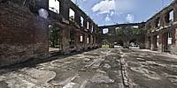
Panorama of the former warehouse for ammunition of the Fortress of Zeelandia, Paramaribo, Suriname.

Location Map Geographic Coordinates:
Latitude: 5° 49' 35" N
Longitude: 55° 8' 59" W
arrow Show at MultiMap.com [what is MultiMap?]
arrow Show at Google Maps [what is Google Maps?]
arrow Show in Google Earth* [what is Google Earth?]
* requires Google Earth
installed on your computer

Date/Time:
June 21, 2010


text
WWP Home arrow right This Event arrow right Indices: Alphabetical | Regional | Thumbnail | Map previousPrevious | Nextnext