
Lost in History
Jake Schaubert Farmstead, Kidder County, North Dakota, USA
June 20, 2010, 11:56 (1656 UTC)

Loading panorama viewer ...
Configuring ...
© 2010 David Schaubert, All Rights Reserved.
Caption
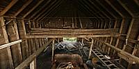
Left behind by the flow of time, the main barn at the Jake Schaubert Farmstead slowly decays. The interior is strewn with the flotsam of the past; a John Deere G tractor, broken down snowmobiles, and various pieces of equipment once used on a productive wheat farm.
Location
Lat: 47° 19' 11.05" N
Long: 100° 36' 51.45" W
Elevation: 575
Precision is: High. Pinpoints the exact spot.
Equipment
Canon XTi (400D) DSLR, Peleng 8mm fisheye lens, Velbon Neopod 6 Monopod, Nodal Ninja 3 (NN3) Pano Head, Apple MacBook Pro 2.66 GHz i7, PTGui Pro 8.310 PRO, Bracketeer, Photoshop CS5 Extended, CubicConverter 2.2.1
 Tap or click the zoom icon in the bottom right corner of the picture to switch between in-page and fullscreen view