
Palaeolithic Station Babja Jama
Gorjuša, Dob, Domžale, Slovenia
June 25, 2010, 21:55 CEST

Loading panorama viewer ...
Configuring ...
© 2010 Boštjan Burger, All Rights Reserved.
Caption
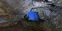
"Baba" means in the Slovenian folks language "Woman" and "jama" is a "cave." This cave was used as a shelter for women and children in a time of the Osmani plunder in the 15th and 16th Centuries.Palaeolithic station Babja jama: during the research of all caves in the spring of 1967 the attention of the archaeologist drew a modest cave Babja jama. Their good position and easy access enabled sounding. In the depth of 1.8m were in sediment, course gravel mixed with loam found first bone fragments, pieces of charcoal and a flint tool.
Systematic excavation started in the summer of 1968. Palaeolithic remains were found in the depth of 2.5m, in the depth of 3m they reached the solid breccia with no more remains.
In 1972 the members of the Society for the Cave Research Simon Robič Domžale started to dig a connection between the two caves, Babja jama and Železna jama. They found bones and artifacts and stopped the dig. Archaeological research started in 1972 and 1973 and included the whole cave. In the spring of 1987 some of the young people helped the archaeologists with the excavation in front of Babja jama.
Bones and teeth of Holocene and Pleistocene mammals were found in the cave. Most bones were broken, sharp edges of the fragments, some showed also traces of fire were remains of the hunters prey from the ice age. There are bones of reindeer, marmot, lemming, beaver, moose and bison. This shows the great variety of the temperature in the Pleistocene period and migrations of the animals connected with that. Many tools of the ice age hunters were found too. These findings in the Babja jama are between 1,200 and 15,000-years-old.
Location
Lat: 46° 8' 8.09" N
Long: 14° 38' 17.99" E
Elevation: 329 m
Precision is: Unknown / Undeclared.
Equipment
Nikon D90, Sigma 8 mm, Led Lenser X21 (light painting method)
 Tap or click the zoom icon in the bottom right corner of the picture to switch between in-page and fullscreen view