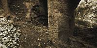

Ruins of Limekiln, the Start of the 19th Century.
Tallinn, Estonia
June 27, 2010, 21:50 local time

Loading panorama viewer ...
Configuring ...
© 2010 Andrew Bodrov, All Rights Reserved.
Caption
I saw these ruins long ago, but have always lacked the time to look in more detail. Every day I pass this place by on the way home. It is a 5-minute drive from the city center, next to the Song Festival Grounds. When I heard about the theme of the next WWP event - I just got the idea to photograph these ruins. When I started asking my friends - know anyone history of these ruins, then no one could tell me anything. Eventually, I found information in a public register of ancient monuments. Below is translation from the Estonian text:
In the end of 18th Century on Lasnamäe slope, on the current Valge Street, was built a huge warlike settlement Uuslinna. As buildings were wrongly constructed from with thick and wet flab-stone walls, living there became unusable, and settlement was slowly pulled down in the coming decades. A large part of the demolition of the buildings from the slopes below were burned into limestone using melting furnaces, including this Hundikuristik melting furnace, which was built by industrialist Georg Eggers. It was then one of Tallinn's most recognizable smelteries.
In 19th Century on a large Hundikuristik melting furnace was built one of the first structures in Russia, where peat was used as the industrial fuel. From the furnace bottom slope the stones were transported to the top, to support the arch-bridge of the transportation road. Later, on top of the furnace is modeled the observation deck.
In addition, on the site with furnace was also situated one wooden cottage (originally probably a production building) and a number of ancillary buildings, which Narva Road extension has demolished. But still retains so called “old Eggers house” and a garden at Narva mnt 120’s ground.
Equipment
Taken with an Canon 5D MarkII digital SLR, Sigma 8mm Fisheye. Mounted on a Nodal Ninja 5. Stitched with PTGui and Panorama Tools.
 Tap or click the zoom icon in the bottom right corner of the picture to switch between in-page and fullscreen view