
Stepping Back in Time for a Pint
The Three Kings, Hanley Castle, Worcestershire, England, UK
June 21, 2009, 18:33 UTC (19:33 local time)

Loading panorama viewer ...
Configuring ...
© 2009 Robert Bilsland, All Rights Reserved.
Caption
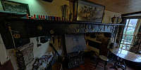
Every week I step back in time for a drink and I wouldn't change a thing. No fruit machines, no jukeboxes, no free Wi-Fi access, just good beer and good conversation. What else would you want?Sue always has a good selection of real ales that are kept in good condition. You can see the great selection of beers that was available at the time listed on the chalk board on the right-hand side of the serving window.
As you can tell this isn't a new pub, far from it. This building is listed as being a pub (or inn) since the 15th century and I'm glad to say not much has changed over the years. It's what gives the place it's atmosphere.
If you're ever passing by then please pop in and have a beer or two, it'll be worth it. And if you do, tell Sue I sent you.
Location
Lat: 52° 4' 34.15" N
Long: 3° 15' 13.21" W
Elevation: 75ft
Precision is: High. Pinpoints the exact spot.
Equipment
Taken with a Nikon D300 and a Nikkor 10.5mm f/2.8G fisheye lens. Mounted on a Nodal Ninja 5 panoramic head atop a Manfrotto 055XPROB tripod. 5 bracketed shots (-4 -2 0 +2 +4) taken at 6 positions 60° apart, tilted 15° down and another set of shots taken looking straight up. Raw files then processed in Nikon CaptureNX 1.3 before being stitched and fused together using PTGui Pro 8.2.1 / Smartblend 1.2.5 and converted between projections using Pano2VR 2.3 beta 1.
 Tap or click the zoom icon in the bottom right corner of the picture to switch between in-page and fullscreen view