
Valencia Regional Exhibition of 1909
Valencia, Spain
June 22, 2009, 14:30 UTC (16:30 local time)

Loading panorama viewer ...
Configuring ...
© 2009 Paco Lorente, All Rights Reserved.
Caption
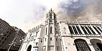
This year, 2009, is being celebrated at Valencia the 100th Anniversary of the Valencia Regional Exhibition of 1909. At that time, Valencia took the initiative to promote the city in search of greater prestige and following the model initiated by other major European cities (London, 1855, Barcelona 1888, Paris 1902).Once completed, the vast exhibition center was demolished with the exception of several buildings, between them this "Palacio de la Exposición." At the present time and until the end of August, it includes a complete exposition of the event and at the end you can visit the main hall of the palace, where was held several official parades.
This panoramic view, shown in black and white, represents the memory of the typical postcard that Valencians usually associate with this event. Most of them do not know where this building is located.
Location
Lat: 39° 28' 23.56" N
Long: 1° 22' 45.4" W
Elevation: 155
Precision is: High. Pinpoints the exact spot.
Equipment
Canon 40D, Tokina fisheye 10-17mm at 10mm, handheld, PTGui
Exposición Regional de Valencia de 1909 [spanish]
Este año 2009 se celebra el 100 aniversario de la Exposición Regional de Valencia de 1909. Valencia tomó en aquellas fechas la iniciativa de promocionar la ciudad a la búsqueda de un mayor prestigio siguiendo el modelo ya iniciado por otras importantes ciudades europeas (Londres 1855, Barcelona 1888, París 1902).Una vez finalizada, el extenso recinto ferial fue demolido a excepción de varios edificios singulares, entre los que se encuentra este Palacio de la Exposición. En la actualidad y hasta finales de agosto se incluye una completa exposición del evento y cuya guinda final es la visita al salón principal del palacio, donde se celebraron diversas recepciones oficiales.
La vista, mostrada en blanco y negro, representa el recuerdo de la típica postal que los valencianos suelen asociar a este evento, pero cuyo edificio la mayoría desconocen.
 Tap or click the zoom icon in the bottom right corner of the picture to switch between in-page and fullscreen view