
24 Hours Have Passed
Schweinfurt, Germany
June 20 & 21, 2009, 9:23 UTC (10:23 local time)

Loading panorama viewer ...
Configuring ...
© 2009 Jürgen Matern, All Rights Reserved.
Caption
Theme
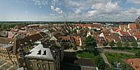
When I checked my schedule to plan the shoot for this event, it was clear to me that I wouldn't be in my hometown at the time of shoot. Sometime later all bookings were arranged and I had a reservation for the Panorama Hotel in Schweinfurt! So in my opinion it was mandatory to shoot a panorama, which at least incorporated the Hotel itself.On location I discovered a nice balcony which provided a nice view over Schweinfurt. So I did a mini-timelapse of this view. The first shot was done on June 20 @ 10:26 am, the second shot on June 21 @ 10:20. The resulting panorama shows both days in a single sphere. If you look up, you will notice the different layout of the clouds on the different days.
Making Of
The shooting was done with a 3.15 meter (appx. 10.33 ft) pole to reach a more elevated viewpoint above the balcony. The pole was extended to its full length. The lens was mounted with a custom made bracket, which allows to mount the lens to turn around the no-parallax point of the lens.As the lens is a fisheye lens, four pictures easily cover 360°. To be sure I took three exposures at each direction. The exposures were 2 f-stops apart. The best exposed set was chosen before stitching. This was done on both days.
I began stitching with the panorama of the first day. It produced a nice sphere, which only had to be retouched at nadir and zenith. Then the final equirectangular image was loaded into PTGui and used as a reference for the second panorama. Thus the alignment of the two panoramas was good enough, to blend them together into one final image in Photoshop.
Links
Be sure to also check the entry of my brother for this event.
Equipment
- Camera: Sony Alpha 900
- Lens: Sigma 8mm f/4 fisheye
- Mounting: Custom made lens bracket mounted on top of a 3.15 meter (appx. 10.33 ft) pole
- Software: Panotools, PTGui Pro, Smartblend, Photoshop CS3, Pano2VR
- 4 pictures per panorama @ 90° / ISO 200
 Tap or click the zoom icon in the bottom right corner of the picture to switch between in-page and fullscreen view