

Loading panorama viewer ...
Configuring ...
© 2009 Ingemar Bergmark,
Some Rights Reserved.

Caption
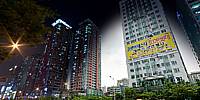
My contribution this time :-) is taken at two times of the day. One during the day and one at night. My original plan was to take a panorama every 6 hours from the same spot, but during my testing I realised that it was not possible to see a major difference between the shots taken in daylight (morning, mid-day, evening), so I decided to just use the panos taken at mid-day and night.
I didn't manage to setup the camera in exactly the same spot, so there are some parallax issues between the two, but I'm quite happy with the result.
The pano shows the main street in Bucheon.
To see more, please visit;
Location
Lat: 37° 30' 14.19" N
Long: 126° 46' 13.05" E
Precision is: High. Pinpoints the exact spot.
Equipment
- Nikon D700
- Tokina AT-X 107 (shaved)
- Manfrotto 055Pro
- Panorama head: Rotopan 7 Mark II
- PTGui Pro
- Photoshop CS3
The main panorama is taken with 4 shots around, plus zenith and nadir to create an equirectangular image. All images are taken in RAW mode, and converted with Adobe Camera Raw.
ISO 200, f/11, 1/320, 6 images
 Tap or click the zoom icon in the bottom right corner of the picture to switch between in-page and fullscreen view