
Nature Park called Parque Ecologico Xochimilco
Mexico City, Mexico.
June 22, 2009, 10:23 local time

Loading panorama viewer ...
Configuring ...
© 2009 Henning Nikolai F. Weber D., All Rights Reserved.
Caption
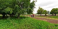
This is a nature park called Parque Ecologico Xochimilco. It’s a park that was designed through conventions with Canada and the United States in order to have these migratory bird paths from North America and re-establish a wetlands to protect the birds. More than twenty species of birds have been visiting. We work closely with the National University of Mexico to reestablish different types of wetlands.The lakes and canals connecting them to one another were first prepared by the Aztecs but had become filled with silt by the mid-20th Century. The canals were restored, a flower market and reception center prepared by Landscape Architect Mario Schjetnan. For this work Harvard awarded him their Green Prize in Urban Design.
Español
Las instalaciones del parque también cuentan con renta de lanchas de remo para navegar por los 14 canales turísticos del lugar; también pueden rentarse bicicletas o cuadriciclos. También hay un pequeño museo y un tren que ofrece una visita guiada por los alrededores. Le recomendamos llevar calzado adecuado para visitar el parque, ya que parte de la visita se hace caminando.
Dentro de este espacio rehabilitado se encuentran 271 especies vegetales representativas de la flora de la región, como el ahuejote. Es el hogar de varias aves residentes y refugio temporal para las migratorias, muchas de ellas procedentes de Norteamérica, como el garzón blanco. Dentro del parque se encuentran las siguientes zonas: reserva natural de las aves, jardín Xochitla, zona recreativa y jardín botánico. También conserva zonas de chinampas (terrenos de pequeña extensión localizados en las lagunas vecinas a la ciudad de México, donde se cultivan flores y verduras). En este espacio natural el visitante puede ponerse en contacto directo con la naturaleza haciendo recorridos a pie.
Equipment
Taken with a Nikon D300 digital camera and the Nikkor 10.5mm f/2.8G ED AF DX Fisheye Lens. Mounted on a Nodal Ninja 5 panoramic rotator head. Stitched using PTGui.
 Tap or click the zoom icon in the bottom right corner of the picture to switch between in-page and fullscreen view