
Set Your Clocks to Megalith Time
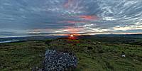
Shee Lugh Cairn Moytura, County Sligo, Ireland
Monday, June 22, 2009, 22:15

Loading panorama viewer ...
Configuring ...
© 2009 George Row, All Rights Reserved.
Caption
Shee Lugh Cairn is one of several megalithic remains on top of Moytura Hill. These include several cairns, a dolmen, a ruined stone circle and multiple ring-shaped earth enclosures. Despite their number, there has been little formal archaeology done there. In the mid 19th Century there was some "exploration" of the main cairn by Lady Louisa Tenison. However if proper records were kept at the time little of them have remained.
What is apparent without excavation is that many of the well known cairns in County Sligo can be seen from this spot and the sunset on the evening of the Summer Solstice goes down over Knocknarea, home to "Queen Maeve's Cairn" - which at 55m in diameter is the largest megalithic cairn in the area.
Unfortunately the weather was rain and mist on the actual solstice so this panorama was taken at sunset on Monday, June 22nd.
"Shee Lugh" literally means "The Seat of Lugh" (that's "seat" as meaning "throne") - Lugh was a Sun God in Irish Celtic Mythology and characterised in several myths as a hero-warrior and King. In one such story he lead the winning side in the "Second Battle of Moytura," which occurred on this site.
That myth concludes with Lugh sparing the life of the defeated King on the condition that he taught Lugh's people "when to plough, when to sow and when to reap". That's one time connection.
Not only does the Summer Solstice sunset, from Shee Lugh, drop behind Knocknarea Mountain. On the Winter Solstice, the Sun sets over one of the most prominent cairns at Carrowkeel on top of the Bicklieve Mountains (the hills above Lough Arrow - the large body of water in the panorama). At the Winter Solstice, the sunrise aligns with Sheemor in County Leitrim; and on the equinoxes the Sun rises over Sliabh an Iariann in the East, and sets over Muckelty Hill in the West. Another time connection!
So despite the lack of formal archaeology it seems likely that these alignments and it's associations with the agricultural calendar in mythology are more than mere chance.
Hence I chose this spot for my "Time" panorama on the assumption that our megalithic ancestors used the sunrises and sunsets seen from here to calibrate their clocks ... or at least their calendars!
The concrete structure to the left of the opening shot (rotate a little anti-clockwise) is a modern Ordinance Survey cairn marking the peak and its altitude. If you keep rotating anti-clockwise the seated figure is Siobhan - a local sun goddess who guided me to top of the hill with minutes to spare before the sunset! (There's that "Time" theme again.)
My Thanks are also due to Martin Byrne of the Irish Stones Yahoo discussion group for suggesting this location and mentioning his website .
This location is also included in the Very Ireland website where there is a "Flattened" version of the panorama available as a print.
Location
Lat: 54° 5' 17.5" N
Long: 9° 19' 5.2" W
Elevation: 226m
Precision is: High. Pinpoints the exact spot.
Equipment
Equipment:
Shot with a Canon EOS 5D, Zenitar 16mm Fisheye f/2.8 lens. The camera was mounted on a Kaiden Kiwi panorama adapter on a Manfrotto 190XDB tripod.
Horizontal photographs were taken at 60° angles. A sky shot and two ground shots (in order to exclude photographer's feet) were taken. In order to catch the colour on the clouds extra shots of the sky behind the setting sun were taken a few minutes after the sun had gone below the horizon. Each "shot" consisted of three bracketed exposures.
A total of 33 separate images were combined using Hugin in order to achieve this High Dynamic Range type result.
 Tap or click the zoom icon in the bottom right corner of the picture to switch between in-page and fullscreen view