

Loading panorama viewer ...
Configuring ...
© 2009 Eva LaMar, All Rights Reserved.
Caption
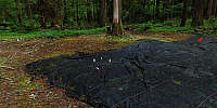
WWP Theme of Time: Research in an old growth coniferous forest is ideal for the theme. DIRT: Detrital Input and Removal Treatments
In 1997, Kate Lajtha, Bruce Caldwell, and Phil Sollins established a long-term field study in an old growth coniferous forest at the H.J. Andrews Experimental Forest to address how detrital quality and quantity control soil organic matter accumulation and stabilization.
The central goal of the DIRT project is to assess how rates and sources of plant litter inputs control the accumulation and dynamics of organic matter and nutrients in forest soils over decadal time scales. The project examines processes at multiple levels, across decades and centuries, exploring the intricate interconnections of biology and chemistry that lead to the formation of humic materials over these hitherto unexplored long time spans. Our plots are part of an informal network of similar experimental treatments that span a significant climatic gradient and that encompass both coniferous and deciduous forests, and that vary widely in anthropogenic N loading.
Current DIRT sites include Harvard Forest, MA (oak forest, established 1991); Bousson Experimental Research Reserve, PA (deciduous forest, established 1992); Síkf?kút Forest, Hungary (turkey oak forest, established 2001), and the Michigan Biological Station, MI (pine forest, established 2004).
HJ Andrews Experimental Forest website: http://andrewsforest.oregonstate.edu/
Location
Lat: 44° 10' 57" N
Long: 123° 14' 45" W
Elevation: 1680
Precision is: Low. Intentionally hazy, due to privacy concerns.
Equipment
Hardware:
Nikon D70s with a Nikkor 10.5 fisheye lens, Nodal Ninja head, Kaidan leveler, tripod. Stitched on a Mac.
Software:
PTGui Pro, Photoshop CS3, CubicConverter
 Tap or click the zoom icon in the bottom right corner of the picture to switch between in-page and fullscreen view