

Loading panorama viewer ...
Configuring ...
© 2009 Alain Sauter,
Some Rights Reserved.

Caption
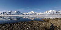
Time is a very large subject and so a very difficult subject too.I spent my first solstice in Svalbard, with 24 hours of light in a day. I imagine first fixing the track of the Sun each hour but Svalbard weather is not easy and I didn't have the luck to get 24 hours of great and dry weather... So I took this picture at 4 am just when a bright Sun appeared to show you how it can be magic here. By the way, I'm in Svalbard as a Field Assistant to study a glacier and it's dynamic throughout years, one more link with "time."
We are situated in the French station "Corbel" in the Kongsforjen about 79° N. Our program is called "hydro sensor flow, loven east" and takes part of the International Polar Year. We are close to the village of Ny Alesund, the northern-most human community of the world. So it seems to be the northern-most panorama of this event.
Equipment
Konica Minolta Maxxum 5D, Tamron 17-50mm, home-made panoramic head
 Tap or click the zoom icon in the bottom right corner of the picture to switch between in-page and fullscreen view