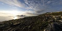

Elevated View of Bodø, Salten and Landego
Keiservarden, Bodø, Norway
22. june 2008, 21.30

Loading panorama viewer ...
Configuring ...
© 2008 Tord Remme, All Rights Reserved.
Caption
The elevated view of the city of Bodø, with the Landego Island and the Salten Fjord. Panorama is taken from a nearby mountain Keiservarden at 09:30PM. The sun will not go down at all this night, but starts rising as soon as it is hidden behind the island. (North is just to the right of the large Landego island). This is one of my favorite spots for recreational outdoor trekking, I have walked this route hundreds of times at all times of day/night and year. Walking to the summit during the (few) sunny summer nights are always a highlight - like pure vitamine injections! The Lofoten Islands can barely be seen in horizon in the north, and the mountains to the south are Børvasstindan. My faithful dog Juju can be seen sitting waiting nearby.
Truly an elevated moment.
Location
Lat: 67° 18' 49.58" N
Long: 14° 28' 29.87" E
Elevation: 300
Precision is: High. Pinpoints the exact spot.
Equipment
Canon EOS 30D, Sigma 8mm f/3.5, 360Precision pano head, Manfrotto tripod. iMac 24", Photoshop CS3, PTGui, Graphic Converter
 Tap or click the zoom icon in the bottom right corner of the picture to switch between in-page and fullscreen view