
11,000 Feet Above Puget Sound
Flight 2383 Victoria to Seattle, Washington, USA
6/22/2008 11:52:44 MST

Loading panorama viewer ...
Configuring ...
© 2008 Shawn Steigner, All Rights Reserved.
Caption
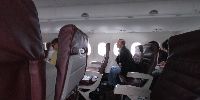
From Seat 18A, a cloudy view above the San Juan Islands is all that can be seen out the window.Returning from assignment on Vancouver Island, this panographer had run out of time to come up with something really creative for the theme of elevation. So I went with the very literal meaning. The specific altitute isn't known but the pilots said we cruised at about 11,000 feet. And we were well into the 40 minute flight so I'm pretty sure we had crossed the international boundry that lies between Canada's Vancouver Island and America's Washington State. Although not technically perfect, this pano came out better than anticipated given such close quarters and such an unstable platform.
Location
Lat: 48° 21' 35.64" N
Long: 124° 10' 4.48" W
Elevation: 11,000 Feet
Precision is: Low. Intentionally hazy, due to privacy concerns.
Equipment
Hard-Canon 40D, Sigma 8mm/f:4, Bogen 300N Rotator, Custom Ring, Mini-TripodSoft-Canon DPP, PTGUI, PhotoShop, Pano2QTVR, IrfanView
 Tap or click the zoom icon in the bottom right corner of the picture to switch between in-page and fullscreen view