
1,395 ft and 3 hours, 33 minutes 'til the Solstice
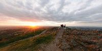
The Worcestershire Beacon, Herefordshire / Worcestershire, England, UK
June 20, 2008 - 20:26 UTC (21:26 Local Time)

Loading panorama viewer ...
Configuring ...
© 2008 Robert Bilsland, All Rights Reserved.
Caption
With the weather forecast for the next day looking bad, I decided to shoot earlier and at a different location. Luckily for me I live on the side of the Malvern Hills, so getting a new elevated location was not a problem. A quick 10 minute drive followed by a brisk 15 minute walk and I was on the top of the hills, on the Worcestershire beacon.I timed the walk to get there just before sunset and was expecting a quiet summit. But when I got there, there was quite a small crowd. A couple who were finishing walking the complete length of the hills, someone quietly sitting meditating, a complete Scout pack (passing through in groups) and three other people who had walked up from where I had parked.
Starting off looking north (to the right of the setting sun) you can see the toposcope, a 25 inch brass disc engraved with a 360° circular map of the surrounding view. While to the south you can see Ordinance Survey triangulation station (or trig point) TP0724. The Malvern Hills also form a part of the county boundary between Herefordshire (to the west) and Worcestershire (to the east).
As you can guess, just after the panorama was shot the sun dipped below the horizon and along with the sun went the temperature too. After such a nice warm day the night time temperature was quite a contrast.
Worcestershire Beacon - Wikipedia
The Toposcope
Triangulation station - Wikipedia
Trigpoint TP0724 - Malvern
The Toposcope
Triangulation station - Wikipedia
Trigpoint TP0724 - Malvern
Location
Lat: 52° 6' 17.56" N
Long: 3° 21' 20.35" W
Elevation: 1,395 ft
Precision is: High. Pinpoints the exact spot.
Equipment
Taken on a Nikon D300 with Nikkor 10.5mm f/2.8G Fisheye lens. Mounted on a Nodal Ninja 5 Lite panoramic head atop a Manfrotto 055XPROB tripod. 6 shots taken 60° apart, tilted 15° down and a single zenith shot. Raw files then processed in Nikon CaptureNX before being stitched together using PTGUI / Smartblend and converted to a QTVR Cube using Pano2QTVR Pro.
 Tap or click the zoom icon in the bottom right corner of the picture to switch between in-page and fullscreen view