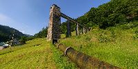

Difference in Elevation: 30 Meters
Oberried, Black Forest, Germany
June 19, 2008, 09:30 local time

Loading panorama viewer ...
Configuring ...
© 2008 Reinhard Schmolze, All Rights Reserved.
Caption
The difference in elevation between the top of the stone tower and the bottom of the big sloping pipe amounts to 30 meters. Since 1911 this small hydroelectric powerplant produces electricity. The rivulet Brugga, coming down from the Black Forest, is retained in the tower and thus builds up sufficient pressure. Two turbines with 220 and 400 kilowatt respectively produce 3 million kilowatt hours per annum.
Equipment
Pentax IST Ds, Pentax 20mm, Manfrotto SPH303, Realviz Stitcher 5.5
 Tap or click the zoom icon in the bottom right corner of the picture to switch between in-page and fullscreen view