

Loading panorama viewer ...
Configuring ...
© 2008 Pat Rooney, All Rights Reserved.
Caption
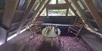
For the solstice I embarked on a long but quick trip to see friends get married. My accommodations were quite lofty. The horse barn's loft as a matter of fact.
Location
Lat: 47° 23' 45.64" N
Long: 123° 25' 57.82" W
Elevation: 245 feet, 75 meters
Precision is: Medium. Nearby, but not to the last decimal.
Equipment
Canon 300D, Sigma 8mm f/3.5, hand held, PTGui Pro on a Mac.
 Tap or click the zoom icon in the bottom right corner of the picture to switch between in-page and fullscreen view