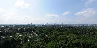

An Elevated View of the Town
Municipal Forest, Frankfurt, Hessen, Germany
June 21st 2008, 04:48 pm CEST

Loading panorama viewer ...
Configuring ...
© 2008 Joakim Löber, All Rights Reserved.
Caption
A nice view from the Goetheturm in the south of Frankfurt.
For contact information and more panoramas of Germany, check my personal website, kugelblick.de
Location
Lat: 50° 5' 20.4" N
Long: 8° 42' 40.9" E
Elevation: 188m
Precision is: High. Pinpoints the exact spot.
Equipment
Nikon D300 with Nikkor 10.5 mm, Manfrotto QTVR Kit 302+, stiched with PTGui (PC) / MakeCubic (Mac), nadir inserted with PaintShopPro on a PC.
 Tap or click the zoom icon in the bottom right corner of the picture to switch between in-page and fullscreen view