
Elevation
Donostia - San Sebastián, Basque Country, Spain
June 19, 2008 - 08:45 UTC (10:45 local time)

Loading panorama viewer ...
Configuring ...
© 2008 Iñaki Rezola, All Rights Reserved.
Caption
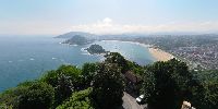
Mount Igueldo offers the highest spot -in fact I should say the tower on the pano does, but it was closed- and reputedly the best panoramic view in Donostia - San Sebastián. You may see Santa Clara island in the middle of the bay.For doing it and to get a wider view I elevated a monopod in the air -so this is not a regular pole-panorama.
Location
Lat: 43° 19' 16.83" N
Long: 3° 1' 31.31" W
Precision is: Medium. Nearby, but not to the last decimal.
Equipment
Nikon D300 + Nikkor 10,5, Monopod (Manfrotto 790B), homemade panohead, Nikon Capture NX, PTGui-Panotools, Smartblend, Photoshop, Spheretocubictosphere, Noise Ninja, Pano2VR
Elevación
El monte Igueldo es el punto más elevado de Donostia- San Sebastián -en realidad el punto más elevado es la torre, antiguo faro, pero estaba cerrado. Se considera también la mejor vista panorámica de la ciudad. Puede verse la isla de Santa Clara en el centro de la bahía.Para hacer el panorama elevé en el aire mi monopod, no se trata, pues, de un panorama hecho con la cámara situada en lo alto de una pértiga.
Goragune
Igeldo mendia Donostiako punturik altuena da -zuzen hitzeginda bertako dorrea dela esan beharko nuke- eta handik hiriaren bistarik ederrena ikus daiteke. Santa Klara uhartea badiaren erdian nabarmentzen da.Panorama egiteko airean nire monopoda altxatu nuen, hau ez da beraz pertika baten bidez egindako argazkia.
 Tap or click the zoom icon in the bottom right corner of the picture to switch between in-page and fullscreen view