
Mols Bjerge - Nationalpark in Denmark
Djursland, Mols, Denmark
June 21 UTC 17.00 - 19.00 local time

Loading panorama viewer ...
Configuring ...
© 2008 Hans Nyberg, All Rights Reserved.
Caption
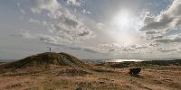
Mols Bjerge or in English the Mountains of Mols is by no means what you would call mountain in most countries.But in Denmark the highest elevation is 170 meters and even if The Hills of Mols are only 137m at the highest point they are still called mountains. And at the place you stand you have one of the most beautiful views in Denmark.
The Hills of Mols is one of Denmark's most fascinating landscapes. It was created during the last Ice age 4-15.000 years ago. The area is protected by the Nature Conservation Act since 1976. You can access the area by by car.
Since January 2008 it has been elevated from a protected area to become one of the 5 coming National Parks in Denmark
The area has fourteen Bronze Age burial mounds of which you see 2 here at "Trehøje" The 3 Hills. The last grave mound is hidden behind the one to the left of the sun.
Location
Lat: 56° 12' 16.66" N
Long: 10° 31' 51.74" E
Elevation: 124
Precision is: Unknown / Undeclared.
Equipment
Canon 5D - Tokina 10-17mm at 14mm - NodalNinja3 - PTGui 7.8 - Enfused with Bracketeer - CubicConverter
 Tap or click the zoom icon in the bottom right corner of the picture to switch between in-page and fullscreen view