
Baseline Ireland
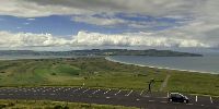
Magilligan Plane, Lough Foyle seen from Bishop's View, Co Derry, Northern Ireland, UK
20 June 2008 - 15:00 UTC (16:00 BST)

Loading panorama viewer ...
Configuring ...
© 2008 George Row, All Rights Reserved.
Caption
In 1820 the first Ordinance Survey of Ireland began under the leadership of
Lt. Col. Thomas Colby. It took 28 years to complete the mapping of Ireland at a scale of six-inches to the mile.The motivation was to obtain the land measurements needed to facilitate a property based taxation system that the British government in London was planning to introduce in Ireland. Hence the surveyors were not always greeted with simply "academic interest" by the locals. Brian Friel's play Translations dramatised some of the cultural clashes.
Nevertheless it was to be the world's first large scale survey of an entire country and in order to complete it the engineers, mathematicians and surveyors charged with the task, invented new methods and devices.
These devices included Colby's compensating-measuring-bar (which was used for making precise measurements of horizontal lengths without being affected by variations in temperature) and Drummond's limelight (which was used for making one trigonometric point visible to surveyors at another). The limelight was later to become a familiar gadget in the theatre.
Why is all this relevant to this panorama?
Well the coastal plain depicted in the panorama was the location of the "baseline" for that first Irish Ordnance Survey and this panorama was shot from one of the trigonometric points used to start projecting a system of triangles from the baseline around the whole country.
The surveyors measured the baseline as 41,641 feet long. It required more than 60 days of active measurement across the summers of 1827 and 1828. There were many interruptions caused by the weather, crossing rivers and fitting in with the harvesting of crops in the fields that they passed through.
The line was re-measured in the 1960s using modern methods and Colby's team was found to have achieved an accuracy of about one inch in eight miles! (That is 1:500,000.)
Having achieved an accurate measurement of the baseline, distances could be calculated around the rest of the country by projecting a system of triangles from the baseline.
The angles of these triangles were measured precisely using a theodolite mounted at a "trigonometric point", often on the top of a hill, targeting other trigonometric points. Once the angles were known the lengths of the unmeasured sides of the triangles could be calculated from other known lengths.
Know one thing well and you can understand the world!
The methods pioneered by Colby were used by Everest in his survey of India in the 1830s.
This panorama then, opens looking over Magilligan Point at the mouth of Lough Foyle. Across the estuary we can see the Eastern shore of the Inishowen Peninsula in County Donegal.
As the panorama starts to rotate anticlockwise you can see the sun twinkling off the water, and off the next shower of rain as it moves down the lough towards us.
As the rotation moves our view inland we pass Binevenagh Mountain, much beloved by those who practice hang-gliding from its cliff tops.
Next our view sweeps across Windy Hill, past the forestry and back to the North Atlantic. On a clearer day we could have glimpsed the coast of Scotland at that point.
For a comprehensive list of the places visible from this triangulation point tilt the panorama down and look at the plaque that has been mounted on top of the pillar itself.
There are lots of panoramic photographs of Derry, just up Lough Foyle on my Very Derry website.
Location
Lat: 55° 8' 57.25" N
Long: 7° 53' 38.94" W
Elevation: 260m
Precision is: High. Pinpoints the exact spot.
Equipment
Canon EOS 5D, with a Zenitar-M 16mm Fisheye f/2.8 lens, mounted on a Kaiden Kiwi panorama adapter.Six sets of bracketed images were shot, plus a set for sky and ground. They were stitched using HugIn (version 0.7) with Enfuse invoked by Hugin to increase the dynamic range. It was rendered as a rotating Cubic-VR using CubicConvertor and CubicConector.
 Tap or click the zoom icon in the bottom right corner of the picture to switch between in-page and fullscreen view