
Waterfall Overlook
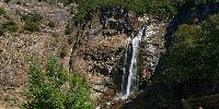
Feather Falls, near Oroville, California, USA
June 20, 2008 11am PDT

Loading panorama viewer ...
Configuring ...
© 2008 G. Donald Bain, All Rights Reserved.
Caption
Far back in the rugged canyons of the Feather River there is a great waterfall - Feather Falls. It plunges 640 feet (195 meters) over a granite cliff. It is just the sort of waterfall one expects in Yosemite, 180 miles to the south, but seldom finds anywhere else. It is protected in the Feather Falls Scenic Area of Plumas National Forest.Feather Falls is on the Fall River, a tributary of the Feather River. This is at the north end of the famous gold country, scene of the great Gold Rush of 1849. The nearest town is Oroville - literally "gold town". It was 107° (41° C) in Oroville the day I went through, but on the eight mile hike to the falls it was pleasantly warm and shaded by thick forest. The forest service has built a sturdy overlook platform, a sheer thousand feet above the gorge, so you don't have to risk your life to get a good view.
See more panoramas of California (and all of western North America) on my website: Don Bain's Virtual Guidebooks.
Equipment
Photographed with an Olympus E-3 digital SLR with an 8mm Zuiko fisheye lens, on a Nodal Ninja VR mount, Acratec Ultimate Ballhead, and Velbon carbon-fiber tripod. Stitched with PTGui Pro 7.8 on a Macintosh Intel Core 2 Duo iMac, retouched with Photoshop CS3, converted to QTVR using Cubic Converter.
 Tap or click the zoom icon in the bottom right corner of the picture to switch between in-page and fullscreen view