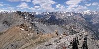

Guglia di Mezzodì
Mountain on the border between France and Italy
June 22, 2008 - 11:15 UTC (13:15 local time)

Loading panorama viewer ...
Configuring ...
© 2008 Fulvio Senore, All Rights Reserved.
Caption
This panorama has been taken from the top of the Guglia di Mezzodì, a mountain on the border between Italy and France. The French name of this mountain is Rocher de Barrabàs.
The small town that you can see in the distance is the Italian town of Bardonecchia: it is one of the locations of the 2006 Winter Olympic Games. France is on the other side of the mountain.
Location
Lat: 45° 1' 20" N
Long: 6° 41' 4" E
Elevation: 2618 m
Precision is: Medium. Nearby, but not to the last decimal.
Equipment
Nikon Coolpix 5000, monopod, PTGui, Enblend.
 Tap or click the zoom icon in the bottom right corner of the picture to switch between in-page and fullscreen view