
A View from Mount Elden
Flagstaff, Arizona, USA
June 19th, 2008 - 1939 UTC (1239 MST)

Loading panorama viewer ...
Configuring ...
© 2008 David Schaubert, All Rights Reserved.
Caption
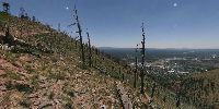
Mt Elden is the remains of an extinct volcano that rises 2400 ft (731 m) above the City of Flagstaff (the peak is 9299 ft/2834 m above sea level). The south side is composed of eroded sandstone and volcanic rock that forms a near vertical face. It is an impressive view from anywhere in the city.I chose to take the panorama from the saddle between the two peaks as this area shows the lingering effects of a forest fire that occurred in 1977. The fire burned so hot that it literally sterilized the soil. Grass has returned but trees are only now beginning to return at the lower elevations.
The ruins of a pueblo (occupied 1070-1275 AD) left by the Sinagua people can be found at the east-side base where the only natural springs in the area provided a dependable water source.
The two highest peaks serve as antenna farms for local television,, radio, and telephone towers and also hosts the regional forest-fire lookout tower as they command the local terrain for miles around. The peak can be reached by numerous hiking trails and also by a road cut into the gentler north side. Numerous meadows are found near the peak as the summit has a relatively flat area to the north.
Mt Elden is part of the greater San Francisco Peaks volcanic system and Mt. Humphreys (the highest point in Arizona at 12,633 ft/3851 m) can be seen 8 miles to the northwest.
http://en.wikipedia.org/wiki/Mount_Elden
http://www.fs.fed.us/r3/coconino/recreation/peaks/elden-pueblo.shtml
http://www.arizonahiking.org/elden.htm
http://southwesthikingtrails.com/mount-elden-lookout-trail-heart-loop-trail/
http://www.fs.fed.us/r3/coconino/recreation/peaks/elden-pueblo.shtml
http://www.arizonahiking.org/elden.htm
http://southwesthikingtrails.com/mount-elden-lookout-trail-heart-loop-trail/
Location
Lat: 35° 14' 32.25" N
Long: 112° 37' 0.18" W
Elevation: 2770
Precision is: High. Pinpoints the exact spot.
Equipment
Canon XTi (400D) DSLR, Peleng 8mm Fisheye Lens, Velbon VGB-3 Tripod, Apple Macintosh 2.8 GHz Dual-Quad Xeon MacPro, PTGui 7.6, Photoshop CS2, Cubic Converter 2.2.1, Cubic Connector 2.0.9.
 Tap or click the zoom icon in the bottom right corner of the picture to switch between in-page and fullscreen view