

Loading panorama viewer ...
Configuring ...
© 2008 Dan Heimsoth, All Rights Reserved.
Caption
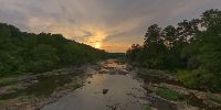
This elevation is not absolute, but the camera location is elevated relative to the rocks and water below. For once the actual time of the solstice was at date and time that allowed me to get out and shoot, so I did. Many decades ago this bridge was the main route over the Haw river for Bynum, NC, a small but thriving mill town back then. Power from a dam located just out of sight upstream was used to power a large textile mill. Now that almost all textile production has moved out of the US, the dam is about all that's left of the mill. The town is now just one more suburb of the Triangle area, although one of the more scenic. The old single-lane bridge was declared unsafe for vehicular traffic, but remains open for walking. Standing on that bridge a few years ago I saw a bald eagle perched in a tree on the river bank, eating a fish for breakfast. It was the first time I had seen a bald eagle in the wild. This particular evening I saw a couple blue herons fishing in the river, but they left before I got my camera set up.
Location
USA-Canada / USA-North Carolina
Lat: 35° 46' 19.2" N
Long: 80° 9' 40.99" W
Elevation: 320
Precision is: Medium. Nearby, but not to the last decimal.
Equipment
Canon XTi, Sigma 8mm, Nodal Ninja 3, Photoshop, PTGui, Pano2QTVR.
 Tap or click the zoom icon in the bottom right corner of the picture to switch between in-page and fullscreen view